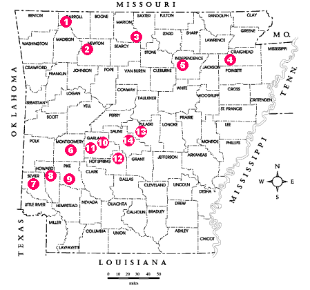
Collecting Locations
Selected Arkansas Mineral Collecting Localities
There are many mineral collecting locations in Arkansas on public property. However, most of the better known sites are on private property, claims on public property, or leases on private property.
This guide is written to describe various mineral collecting locations and is not to be used or construed to be permission to obtain access to sites. Permission should be obtained from owners, lease holders, or companies before collecting any location not on public land. Federally owned or administered properties are controlled by various Federal agencies and certain of these lands, such as Wilderness areas, National Parks, and National Guard training camps are withheld from collecting. Highway right-of-ways (except interstate), navigable streams and the majority of Federal lands are open to hand tool collecting.
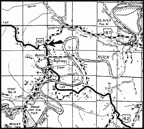
Banded chert occurs 0.2 of a mile north of the Busch Post Office on the east side of U.S. Highway 62. This chert shows concentric banding of light and dark layers and polishes readily.
Source: Arkansas Geological Commission
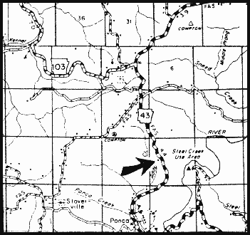
Galena and Sphalerite
Several abandoned lead mines may be reached by Arkansas Highway 43 north out of Ponca. Approximately 2.5 mines from Ponca and near the crest of the hill a dirt trail to the west is passable for a short distance downhill to near the mines. Good hand specimens of galena with minor sphalerite are found in the dumps.
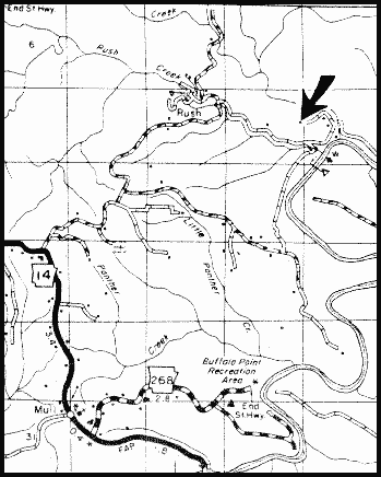
Smithsonite, Calcite, Quartz, Dolomite, Greenockite, and Sphalerite
A number of abandoned zinc mines are in the vicinity of the abandoned mining town of Rush. Take Arkansas Highway 14 north from Buffalo Point Recreation Area entrance (junction of Highways 14 and 168) approximately 2.7 miles to an improved dirt road, turn east, bear left at the first four junctions, then sharply right at the base of the hill.
Some of the old mines are within the boundaries of the Buffalo National River, and as such, collecting is strictly prohibited. If in doubt of the park boundaries, check with a ranger.
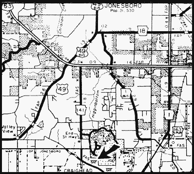
Several gravel pits are located north of a county road which connects Arkansas Highways 1 and 49. Banded agates with shades of brown and tan occur in the gravel beds of this area.
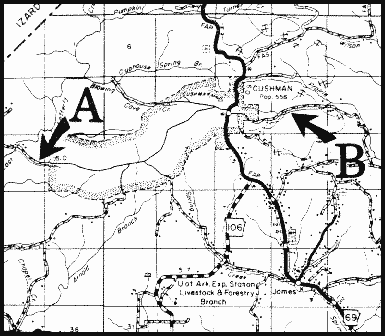
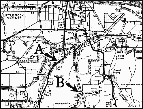
Phosphate rock (A) and Manganese ore (B)
(A) Phosphate rock occurs in a county road ditch 0.6 of a mile east of East Lafferty Creek. The phosphatic nodules are black when fresh and have a white coating upon weathering.
(B) Manganese ore is found 1.2 miles east of the county road and Arkansas Highway 69 in Cushman. Manganese minerals found in this area are psilomelane, braunite, pyrolusite, and hausmannite.
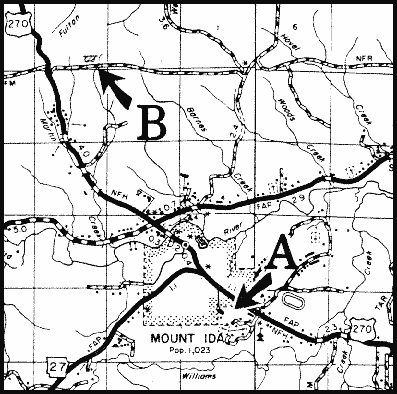
Quartz (A) and Wavellite (B)
(A) Located within the city limits of Mount Ida, Sonny Stanley's crystal yard displays quartz and other mineral from this area. Mr. Stanley is one of several operators of fee-pay crystal mines in Montgomery County. See also the Quartz chapter.
(B) Northwest on U.S. Highway 270 approximately 3.5 miles from Mount Ida, turn right(east). Wavellite occurs at the county quarry, located approximately 0.7 of a mile east and on the north side of the road.
Antimony
To reach an abandoned antimony mine, turn north off U.S. Highway 70, 0.5 of a mile west of the Sevier-Howard County line. Proceed about 2.2 miles north past the turnoff to the Jefferson Ridge use area. Turn west (left) onto Weyerhaeuser Road No. 50,000. Proceed 3.6 miles (the second dirt crossroad) and turn right (north). Approximately 0.3 miles north is a faint crossroad. At this crossroads, the dump pile from the mine is on the northwest corner.
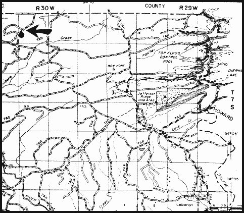
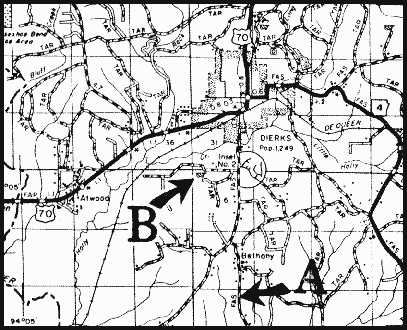
Celestite (A) and Barite (B)
(A) Celestite is exposed in a Howard County road ditch about 3 miles south of Dierks.
(B) Sand cemented by barite crystals is exposed in a small exploration pit one mile south and 0.75 of a mile west of Dierks.
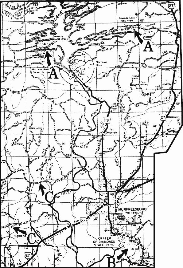
Cinnabar (A), Diamonds (B), Gypsum (C)
(A) Cinnabar occurs at the end of the cove between the Pikeville public use area and the Parker Creek use area on lake Greeson; and 2.2 miles west of Arkansas Highway 27 in the road ditch.
(B) The Crater of Diamonds State Park. A daily fee is charged to hunt for diamonds.
(C) Gypsum, celestite, and various fossils occur in gypsum mines north of Highland.
Quartz Crystals
Fee pay commercial mines near Jessieville. See Quartz Crystals section.

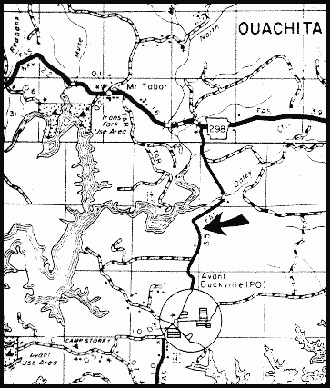
Wavellite and Variscite
On a county road approximately 1.8 miles north of Avant, wavellite and variscite occur in the road ditch and on the hill to the east.
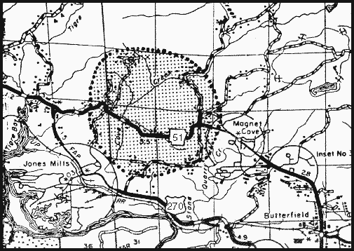
(A) Sphene nepheline syenite occurs at the curve on the north roadbank on Ark. Highway 51 about 0.5 miles west of Cove Creek.
(B) Carbonatite occurs in the north road bank just west of the Cove Creek bridge on Ark. Highway 51. Locally, the carbonatite contains carbonatite-apatite, monticellite, magnetite, perovskite, kimzeyite, and biotite.
(C) A boulder containing eudialyte nepheline syenite pegmatite is near the southwest corner of the Cove Creek bridge abutment just south of location B.
(D) Weathered biotite, melanite garnet and residual masses of nepheline occur in the south bank of Ark Highway 51, near the Magnet Cove Church.
(E) Magnetite, melanite, nepheline and rutile may be found on the shoulders of Ark Highway 51, 0.25 of a mile east of the Magnet Cove Church.
(F) Pyrite occurs in Cove Creek approximately 0.2 of a mile east of the iron bridge (paved crossroad north from Highway 51, west of Magnet Cove cemetery).
(G) Smoky quartz and brookite occur on a small hill due south of the cemetery at the junction of Ark Highway 51 and the barite mine road (N.L. Baroid sign on Highway 51)
Syenite
(A) A variety of syenite termed Pulaskite occurs 0.3 of a mile south of Fouche Creek on Arkansas highway 367.
(B) Nepheline syenite occurs along the road ditch at the Dixon Exit on U.S. Highways 65 and 167. Also, nepheline syenite and pulaskite are exposed in road cuts north on U.W. Highway 65 from this junction.
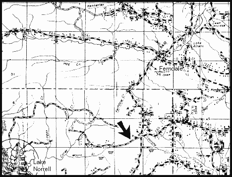
Talcose Shale
Talcose shale occurs approximately 3.5 miles south and 0.7 of a mile west of the community of Ferndale. This exposure is close to soapstone mineralization exposed in nearby pits.
A synopsis of a handout entitled "Rockhounding, Mineral Collecting, and Our National Forests" by John Nichols, Retired Forest Geologist, Ouachita National Forest - Feb. 1997
In several National Forests, the Forest Service has developed mineral collecting sites. Examples include sites in Montana, Idaho, and the Ouachita National Forest of Arkansas and Oklahoma. Additional sites are being studied for their feasibility for public rock and mineral collecting. A number of the National Forests already have free literature giving general specimen localities and Forest Service policy and rules for rockhounding. A number of the National Forests have a history of placer gold mining and provide information as to use and restrictions on suction dredging.
There are, however, certain areas designated as off-limits to collectors, principally due to the classification of the land. Restricted lands presently include wilderness areas and designated portions of "wild" rivers. The US Forest Service only manages these areas as set forth by the US Congress (Consequently, it does no good to fuss at the "caretaker" about this situation. If you don't like it, you should become politically active and write your Congressman and Senator. Ed.).
Every collector should become familiar with the laws and regulations under which the Federal Agency administers the public lands the collector wishes to visit. At present, there is no "right" under law for mineral collectors and rockhounders to collect specimens from public lands, like the National Forests. There are some Acts which "open the doors" for us on National Forest lands. They include: the Organic Act of 1897 which recognizes that access to federal minerals is an important use of National Forests to many people. And The Federal Land Policy and Management Act of 1976 (FLPMA). The FLPMA calls for a balance among all the uses to "manage", "protect", "preserve", and "provide".
The activity of collecting generally does not "significantly" impact or disturb other Forest resources. Therefore, by simply contacting the local District Ranger, the collector may find that notification is all that is necessary to receive "permission" to conduct their hobbyist activities. An example is simple digging with hand tools for mineral specimens. If a club desires to collect a site using heavier equipment, perhaps a backhoe to prepare the site by exposing specimens for the club members, and the purpose is for the collection of specimens for personal collections, not to sell or trade, then a District Ranger will need to visit the location before hand, simply to examine the area and determine if other Forest resources might be negatively impacted. If approval is given for such club activity, then a written agreement will be signed to determine who the responsible parties are and what their activities will be restricted to. A bond will probably be required to insure land reclamation after use of the site is over.
Many advanced collectors and clubs are concerned with the advancement of the mineral sciences and education of their membership. Collecting by individuals or clubs who are involved in education by publication of articles in professional or lay journals is considered important by the District Ranger. Access may often be granted for these special collecting activities, by temporarily opening a closed road to assist collectors. District Rangers appreciate the general public's right to study and learn from that study.
So, the key to access for mineral collectors and rockhounders on National Forest land is communication. Make contact with the District Ranger and tell them who you are, where you want to go, and what you want to do. (You may be surprised by the positive response you receive. Ed.)
Mike's Rant: Be honest. If you want to collect minerals for resale or trade, then go through the system that is established for commercial ventures. Let the hobbyists have an unstained reputation. To me, the greatest problem for hobbyists and even serious mineral collectors is the greed of certain individuals who will tell everyone they are hobbyists, then they haul away truckloads and leaving nothing for the next collector. These types of people give all our hobbyists a bad name. If you saw someone back up a truck and start emptying out your neighbor's home, you'd probably call the police right away. I strongly suggest you contact the US Forest Service District Ranger should you see someone cleaning out a locality in the same manner.
The handout with the above information is free upon request from the U.S. Forest Service by writing to: P. O. Box 1270, Hot Springs, AR 71901 or by calling (501)321-5202. John Nichols, a geologist, is also a rock and mineral collector and has considerable empathy with we hobbyist-type collectors. He is very concerned about the recent attempts at regulation of our hobby on public lands without having public comment necessary to obtain a complete picture of the various types of rock and mineral collectors who wish to pursue the hobby and enjoy access to public lands. It is truly refreshing to find someone working for the Federal government that I can say is friendly to our cause. I have been privileged to be involved with John, Albert Kidwell, Henry deLinde, Charles Steuart, and others to try an assist the U.S. Forest Service to define the various types of collectors who utilize public lands. Note that I say collectors, not commercial people. There are already numerous regulations covering the commercial recovery of minerals, both for collectors and industry, on Forest Service lands.
These maps are public information, and can be requested from the Arkansas Geological Survey.
Ask for free publication, AGC miscellaneous publication #19.