
The Geologic Time Scale, and a brief history of how Arkansas was made
 GEOLOGISTS HAVE A warped sense of time. Maybe not as bad as astronomers do, but it is still mind-boggling to think in millions and billions of years.
As best that scientists can figure, the first rocks formed on the earth about 4.5 billion years ago. The earth is maybe 6 billion years old, but took it took a while for the crust to cool off and solidify. The rocks of the earth are the key in determining not only how the world is put together, but how old it is. You've seen places on the side of the road where the rocks lay in horizontal beds on top of each other. These are sedimentary rocks. In those parts of the world where the layers haven't been jumbled together by mountain-building forces, the bottom layers are older. Like a detective, scientists read the clues and can tell the ages of the rocks by the fossils in the layers. Since the 1950's, special techniques have been devised by geologists using radioactive isotopes present in rocks to accurately age date sedimentary, igneous, and metamorphic rocks. Guess what! The age dates correlate well with that of the fossil record found in sedimentary rocks, adding support to the acceptance of the Geologic Time Scale. So, by looking at road cuts, quarries and sections of rock cored by drilling, geologists pieced together a history of the planet.
A scale of time left by the rocks
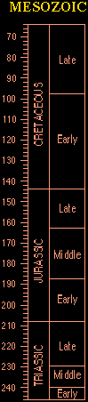
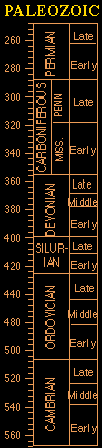
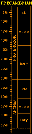
At the left of this page as you scroll down is the time scale of geologic history. The numbers on the left-hand side of the table are millions of years before present time, and in each section of the table, the scale changes. That change means recent events recorded in the rocks are much better known than the older happenings of our earth, and the events of the very early world are mostly unknown. There are no fossils in the oldest rocks because there were no living things. In this geologic column, it is younger on the top than on the bottom, just like the piles of paper on my desk, or a layered sequence of sedimentary rock.
Four major divisions
Roughly, we can divide the time column into units comprehensible to us by saying the Cenozoic was the past time from present day back to the disappearance of the dinosaurs. The Mesozoic was the time that dinosaurs lived, the Paleozoic was before the dinosaurs with fossil plants and sea animals, and the Precambrian is the oldest group of rock: mysterious because so little is known about it. And get a load of this: Precambrian time occupies eighty percent of the earth's history!
On the previous page, we told you some of the active processes that assist the continents in their slow-motion dance around on the planet's surface, bumping and banging together (called plate tectonics), creating mountains when they collide. Volcanoes and erosion are also active forces that shape the land. Volcanoes bring up new material for land, erosion wears it down. That's part of the rock cycle.
 A trip through time
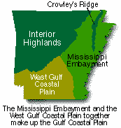
Here is a map showing the regions of Arkansas today. The timeline summary below tells you how our part of the world got like this.
Get your brain into major time-lapse mode, and try to follow the events summarized in this geologic history of Arkansas as we go backwards into time:
Summary of geologic history in Arkansas
Cenozoic Era
Quaternary present back to 1.6 million years before present (MYBP)
Holocene: The early indians lived here in a drier climate than we have now. Wind blown dust and sand dunes, along with stream deposits covered portions of the land, but erosion was also active, and carried away surface material. The Ozark highlands of north Arkansas looked similar to the canyonlands of the western United States today.
Pleistocene: This was the time of the glaciers, but no glaciers reached as far south as Arkansas. The ancestral Mississippi and Ohio rivers delivered *tremendous* amounts of glacial outwash deposits to the eastern part of Arkansas along the river's pathways. Minor alpine snow packs occurred in the Ouachita Mountains, and terrace deposits developed along the major rivers. The northern highlands are greatly eroded, and Crowley's ridge had the Mississippi River flowing on its west side and the Ohio River on its east side, meandering in the eastern part of the state.
Now remember, we're going backward in time ----
Tertiary (1.6-66 MYBP)
Neogene: Erosion happened. No known deposits occurred.
Paleogene
Oligocene: Erosion. No known deposits occurred.
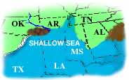
Eocene: There was a very shallow sea receeding from the northeastern half of the state called the Mississippi Embayment, as river and ocean deposits filled it in. The highlands of the Ozark mountains have been eroding away for millions of years, and bauxite, lignite, clay, sand and silt were deposited.
Paleocene: The shallow sea covering southern and eastern Arkansas had limestone reefs near the shoreline, capped by dark marine shale. Bauxite developed on Cretaceous alkalic intrusions (magma that came up from deep in the earth). The highlands were eroding.
The boundary with this unit and the next older one marks the time of the end of the dinosaurs, mass extinction caused possibly when an asteroid collided with the earth, perhaps off the Yucatan peninsula...
 Mesozoic Era
Cretaceous (66-144 MYBP)
Late Cretaceous Shallow water sands, marls, and chalks were deposited in the Mississippi Embayment, along with water-lain volcanics in the lowest unit in this sequence.
Mid-Cretaceous (about 100 MYBP) The downwarping of the earth's crust that formed the Mississippi Embayment allowed shallow seas to invade the middle part of North America as far north as Cairo, Illinois. Alkalic igneous activity began to occur in central and southwest Arkansas, which is now exposed as the areas of Magnet Cove, Potash Sulfur Springs, Granite Mountain, and the diamondiferous pipe at Crater of Diamonds State Park.
Early Cretaceous Dinosaurs were on the land, and the Arkansaurus lived near the coastline of the old Gulf of Mexico in southern Arkansas. Near shore deposits of clay, sand, gravel and limestone were laid down. Very salty lakes or lagoons south of the Ouachita Mountain area resulted in deposition of gypsum and anhydrite.
Jurassic (144 - 208 MYBP)
Aside from the dinosaurs made famous by the movie of this period, erosion of the highlands was continuing in north Arkansas, and sediments from this time are not exposed at the surface in the state. In south Arkansas, deposition of terrestrial redbeds, shallow water shales and limestones occurred, with major salt intervals in the lower sections.
Triassic (208 - 245 MYBP)
The earliest dinosaurs appeared. Sediments are not exposed in Arkansas. Andesitic volcanic action in the extreme southwest corner of the state. The highlands were eroding.
Paleozoic Era
Permian (245 - 286 MYBP)
Sediments not exposed. Erosion of highland.
 Pennsylvanian (286 - 320 MYBP)
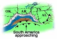
Ouachitas - This is the time of South America, the Caribbean Plate, or another land mass bumping into us, causing the Ouachita Mountains to form. Some of the sediments were squeezed like toothpaste into mountains, while major thrust faults and reverse fault lines formed in the brittle units. The ocean over the area was getting more shallow. Rapid deep water clastic (rock fragment) sedimentation happened.
Arkansas Valley - There was rapid infilling with clastic sediments along the ocean basin growth faults.
Ozarks - The ocean that covered this area had shallow-water clastic sedimentation. Fault lines formed in a NE - SW direction, diagonally across the area.
Mississippian (320 - 360 MYBP)
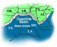
Ouachitas - The ocean was deep early in this period. The slow rates of deposition in the Ouachita trough came to an end with the last beds of novaculite. Sedimentation became very rapid and the ocean started filling in.
Ozarks - Deposition and partial erosion of shallow water limestones, shales and sandstones.
Devonian (360 - 408 MYBP)
Ouachitas - 48 million years of slow deposition of deep water novaculite and shale in the ocean.
Ozarks - Slow deposition and erosion of thin units of shallow-water clastics and carbonates.
 Silurian (408 - 438 MYBP)
Ouachitas - 30 million years of slow deposition of clastic sediment in the deep ocean.
Ozarks - Deposition and partial erosion of thin shallow-water carbonates.
Ordovician (438 - 505 MYBP)
Ouachitas - 67 million years of deposition of alternating sandstone and shale in the deep ocean.
Ozarks - Shallow seas covered the area, with deposition of layers of carbonates with minor clastics.
Cambrian (505 - 570 MYBP)
Ouachitas - The oldest formation that is exposed is the Collier Shale, and geologists don't know how thick it is.
Ozarks - Cambrian rocks are not exposed in north Arkansas. Where clastic and carbonate sediments were deposited form shallow seats on top of the Precambrian igneous basement.
Precambrian
Events in the Precambrian are essentially unknown to us because it was SO LONG AGO and in Arkansas these rocks are not exposed. From sparse well data in the Ozarks, Arkansas Valley, and portions of the northern Mississippi Embayment, the Paleozoic rock layers are underlain by areas of rhyolite, metarhyolite, granite, and microgranite. These kinds of rocks are igneous, meaning they were once molten. Lower Paleozoic rocks in the Ouachitas contain Late Precambrian indicators, so geologists know that the Precambrian rocks are underneath the mountains and all of the other rocks in Arkansas.